


Description
Our Hudson Palisades Trails Map is a five-map set that features 40 miles of the Long Path and more than 60 miles of other trails in the Palisades region of New York and New Jersey along the Hudson River. The maps are printed in vibrant color on waterproof and tear-resistant Tyvek, and are a must-have for exploring the trails and open space in the Palisades region.
The 2023 update includes some significant changes, including:
- New Boulders Loop Trail at Nyack Beach State Park, which combines a new section of trail built by our Long Distance Trails Crew with the Long Path and old Upper Nyack Trail to create a complete loop.
- Improvements to the challenging Giant Stairs area with additional details.
- New inset map showing the newly-opened walkways around the George Washington Bridge, including the route of the Long Path.
- Trail reroutes to several trails in Tenafly Nature Center.
- Several viewpoint additions and adjustments.
- Several new parking access points.
- Improved parkland shading to better differentiate various park and preserve managers.
Map features include:
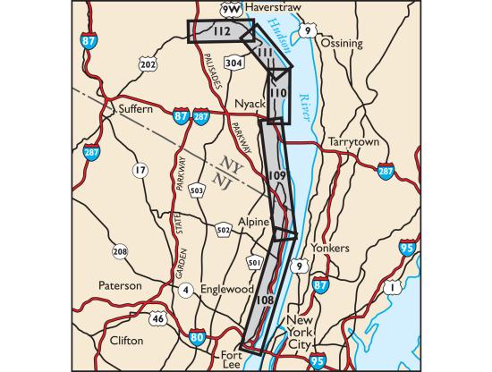
- 100 miles of marked trails and bike paths along the western side of the Hudson River from Fort Lee, NJ northward through Bergen and Rockland counties to Haverstraw, NY
- Parklands including Palisades Interstate Park, Blauvelt State Park, High Tor State Park, Rockland Lake State Park, Tallman Mountain State Park, Buttermilk Falls Park, Clausland Mountain Park, Flat Rock Brook Nature Center, Gurnee Park, Mountainview Nature Park, Rockleigh Woods Sanctuary/Lamont Reserve, South Mountain Park, and Tenafly Nature Center/Lost Brook Preserve
- Approximately 40 miles of the Long Path from the George Washington Bridge north to Mount Ivy
- Detailed trail mileage numbers directly on the map front
- 20-foot elevation contours
- 1:18,000 scale (3.52 inches = 1 mile)
- Convenient map sizes to carry and use on the trail
- Parkland boundaries
- Unmaintained trails and woods roads
- Viewpoints, waterfalls, mines, and other points of interest
- Parking areas
- Public transportation
- Park contact information, history, and regulations
- UTM coordinate grid
- Five-map set, map #s 108, 109, 110, 111 & 112
*ALL SALE ITEMS ARE FINAL SALE*
Disclaimer : All information contained on this page is subject to change without notice. Thruway Sporting Goods is not responsible for discrepancies in pricing, listed information or incorrect images. Please visit us in store for the most up to date pricing, and information.
Recently viewed
Your title
Use this text to share information about your brand with your customers.
Describe a product, share announcements, or welcome customers to your store.